Posts

Showing posts with the label India

Indian Crocodile: Gharial's back into the wild

Image
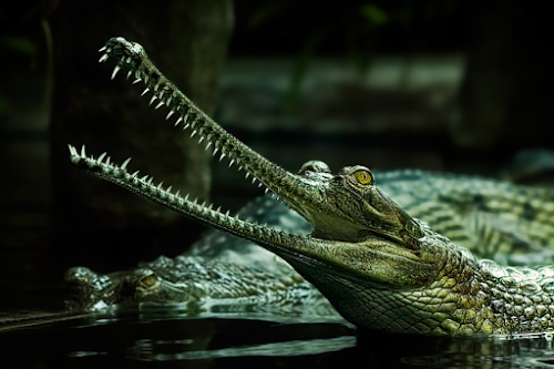
Gharials are blessed with adaptability power and have survived thousands of years by balancing with ecological change. Their adaptability trait is leading them to survive in the wild. The secret of their adaptability trait is higher immunity, fewer predator species,  ectothermy, highly evolved metabolism. They being the top predators, conveniently move between habitats, plays a crucial role in transferring energy between the system. Crocodiles are necessary for the proper functioning of the system, by stabilizing the ecosystem and providing ecosystem services, also creates habitat linkages.   Gharial Status in India There are only three species of Indian Gharial found in India. The Indian species are Gharial, Gavialis gangeticus ( Gemlin 1789); the Mugger, Crocodylus palustris (Lesson 1831); and the Estuarine Crocodile, Crocodylus porosus (Schneider 1801). This species is listed as Critically Endangered on the IUCN Red List (Choudhury et al. 2007) and is considered the most endangered

INDIA: Role of Geo Spatial Technology in Building Nation

Image
  India being a seventh-largest country (3.29 million sq km), fifth-largest economy (GDP $2.96 trillion) and second highest population (1.37 billion) in the world have various challenges in different sectors to sustain the growth and development of the nation. To bridge the social and economic disparity between different sections of society India needs a technological advancement and empowerment of citizens to enhance its system. In the 1980s, India adopted GIS technologies, India is using Remote Sensing Satellites, mapping, Geospatial database system, and other tools. In the early 2000s, a crucial step was taken which was considered to be impossible at that time as creating a blueprint for such a big project is next to impossible. India wants to create its own National Spatial Data Infrastructure. Indian democracy has 3 pillars and the fourth one is considered to be the information sector and this Geospatial database infrastructure is a crucial component of that pillar. The plan is to